The first time I visited Aoraki Mount Cook National Park, I was a tourist fresh off the boat from Malaysia. I’d planned to stay for one night (because even in 2010, accommodation in the area was incredibly expensive) and to do the Tasman Glacier boat ride.
Naturally, it rained for 24 hours straight with heavy winds, and the boat ride was cancelled. I spent most of my short time there indoors – I didn’t leave the village and didn’t even see Mount Cook due to the relentless fog.
The second time I visited, I was older and wiser. My partner and I spent two nights in the national park, and the weather was actually good on one of those days. We did the Hooker Valley and Kea Point walks, and the Hooker Valley walk turned out to be one of the most memorable experiences of my life.
Still, the Tasman Glacier walks were nowhere near my radar at that time. I think it was because Hooker Valley was so popular that it overshadowed everything else there, especially when the entire trail was open pre-2025.
This year, I visited Mount Cook for the third time in my life… and finally, finally, I made it to the Tasman Glacier walks.
And now I’m kicking myself for taking so long to get there, because I seriously think they are just as good as Hooker Valley.
The Tasman Glacier walks
Yes, that’s a big claim, but I’m going to back it up.
So, in Mount Cook National Park, there are two main clusters of walks that are easily accessible to visitors.
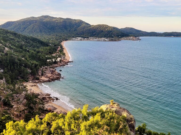
The first cluster starts from White Horse Hill campground near the village, and it includes the popular Hooker Valley walk. These walks focus on Mueller Lake and Hooker Lake, and their respective glaciers.
The other cluster starts from the Tasman Glacier car park, 9km away from the village, and focuses on the Tasman Lake and its glacier.
Both clusters have views of Mount Cook from certain vantage points. We’ll be focusing on the Tasman Glacier walks in this post; I’ve covered the other cluster here.
There are technically four walks in the Tasman Glacier area, but it’s really just two main tracks with one side track each.
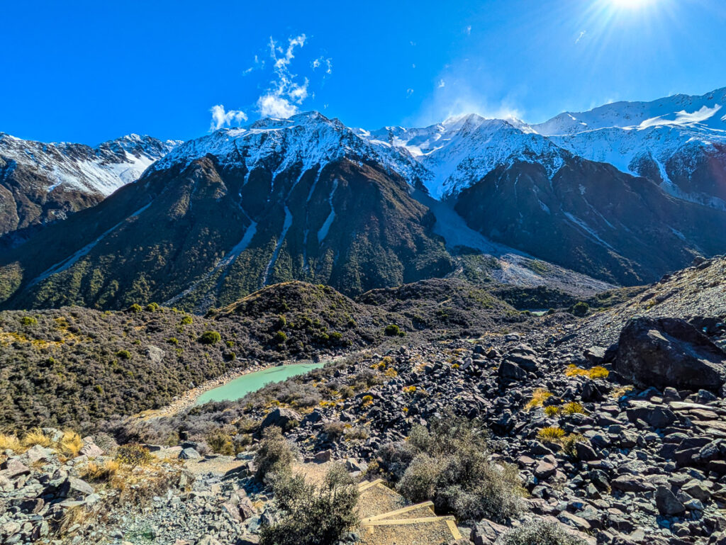
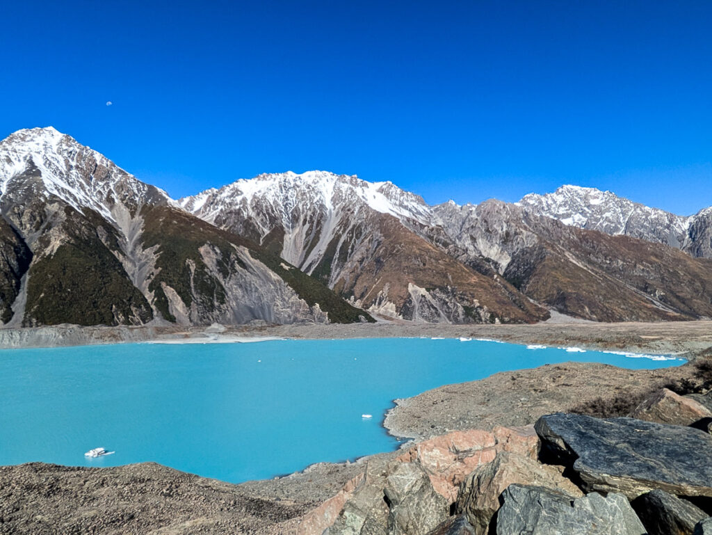
- Tasman Glacier viewpoint (1.5km return): You’ll ascend a (literally) breathtaking number of sturdy, well-formed stairs to reach the viewpoint at the top of the hill, which overlooks Tasman Lake and its glacier in the distance.
- Side track to Blue Lakes (~100m from the fork): A very short side track that leads to the blue lakes, which are really mostly teal in color. You can get all the way up to one of them, but the track to the others is unmaintained.

- Tasman Lake and jetty (2.6km return): This is the walk you’d be doing if you took the boat tour on Tasman Lake. It’s by far the easiest of all the walks here, just a short stroll down a wide, mostly flat and well-formed path from the carpark to the jetty.
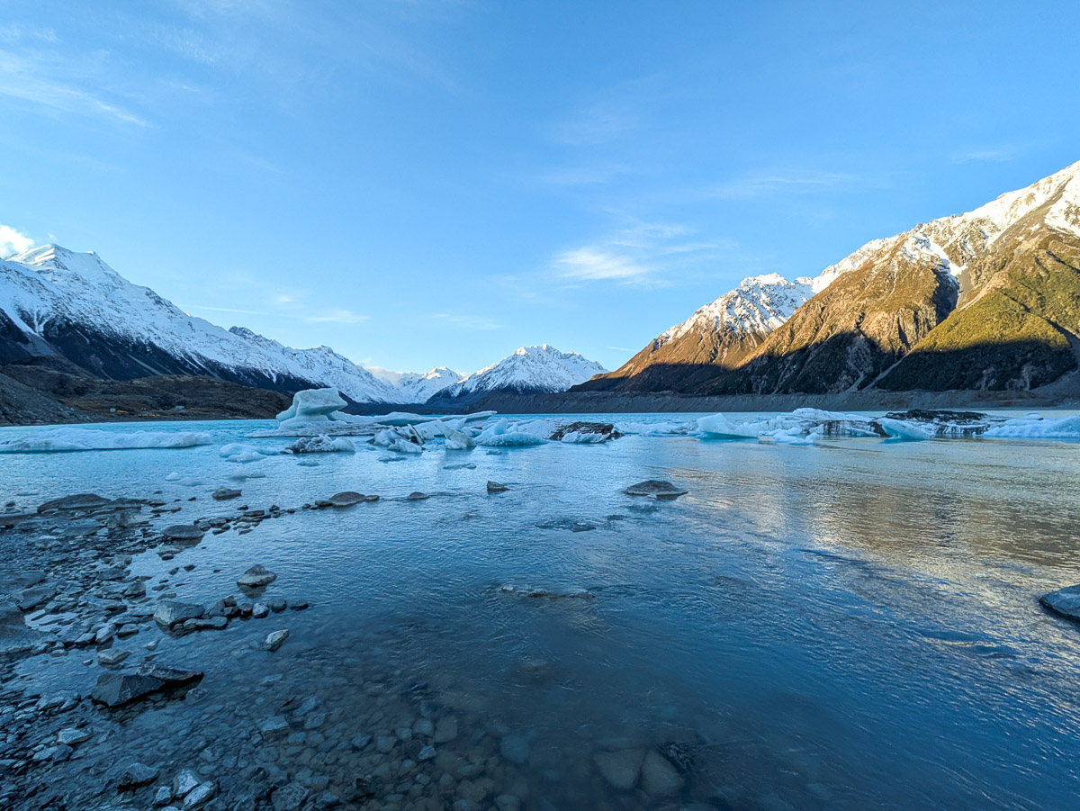
- Side track to Tasman River (~300m from the fork): My favorite out of all the walks here! This track deviates from the jetty track to bring you to the place where Tasman Lake flows into Tasman River. You’ll see an incredible number of icebergs here up close, although getting down to the shore involves a bit of rock scrambling.

I’ll go into the nitty gritty details for each of the tracks here.
Getting there
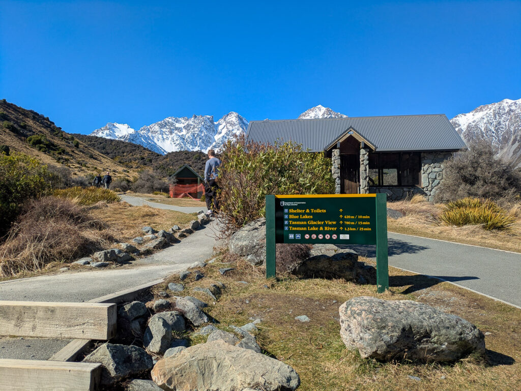
All of these tracks start from the Tasman Glacier carpark. The carpark is a 10-minute (9km) drive from Mount Cook Village, so you’ll need transport from the village to the trailhead.
There is no public transport and no taxis or Uber in the area, so if you don’t have a car, your only option is a shuttle from a tour operator.
To get to the carpark, you’ll drive down Tasman Valley road – it’s a sealed, straight, and very easy drive. You absolutely don’t need a 4WD for this drive, any old sedan will do.

Some car rental companies might say that the Tasman Valley road is off limits, but this restriction usually only applies to the 4WD track AFTER the Tasman Glacier carpark, which takes you to Ball Hut. You don’t need to drive on the 4WD track to access these hikes, so you’re probably good.
When you rent a car, make sure you read the restrictions policy and documentation yourself. Don’t expect to get this information from the employee renting you the car – the person we talked to when we picked up our car didn’t seem to know the difference between the sealed road and the 4WD track, and insisted that the entire road was off limits.
Later that night, we read the documentation on the rental car company’s website and realized that she was wrong. We would’ve missed out on this experience entirely if we had listened to her.
Tasman Glacier viewpoint & Blue Lakes
Tasman Glacier viewpoint (1.5km return)
So. Many. Stairs.
That was the never-ending refrain looping through my head as I slogged my way up to the Tasman Glacier viewpoint. Only 780 meters from the start of the trail – but almost all of it stairs.

On the bright side, the stairs are well-constructed and very even, with wooden planks for extra stability. Which makes it a somewhat accessible trail, really – if you can climb stairs without holding on to the railing, you can do this trail. You won’t need hiking footwear, either – any comfortable walking shoes will do.
Halfway up, you’ll reach the fork that leads to the Blue Lakes side track. Take it – it’s a nice break from the stairs, and even though the lakes aren’t actually blue (more on that later), they’re still quite pretty.
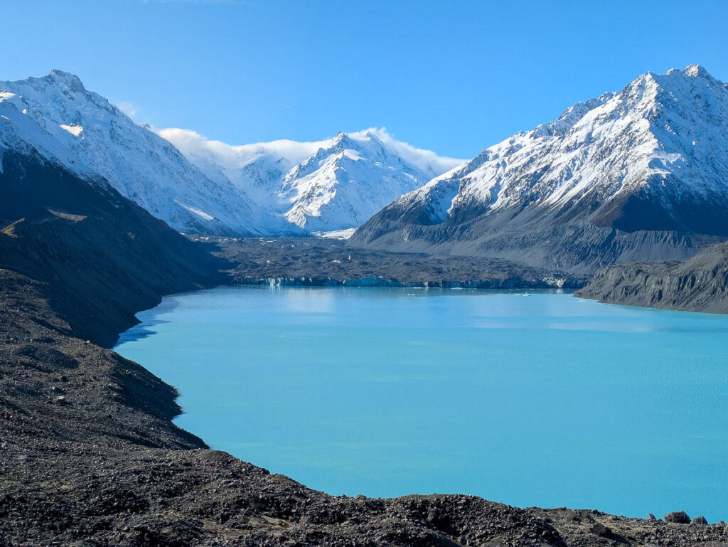
The views at the top are totally worth it – you’ll be looking down on Tasman Lake, its brilliant blue waters shimmering in the sunlight. At the far end of the lake is Tasman Glacier, with snow-capped mountains rising from its moraine walls.

You can see Aoraki Mount Cook on the left hand side of the lake. Its profile feels unfamiliar, compared to the Aoraki that we know from the Hooker Valley or village viewpoints. Seen from this angle, the Low and Middle Peaks appear much further apart.
It was very windy at the top when we arrived – at some points I could barely stand up for fear of getting knocked over by a gust of wind. That was partly due to a South Island-wide weather event (ski lifts were also closed during that time), but the viewpoint itself is also very exposed. Make sure you bring warm and windproof clothing with you.
When you head back down the stairs, you’ll get gorgeous views over the Tasman Valley, as well as overhead views of the Blue Lakes.
Blue Lakes side track
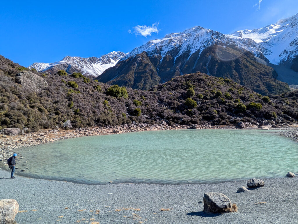
The Blue Lakes is a nice little side trail that you can visit on your way to the Tasman Glacier viewpoint. There isn’t that much to see here, so if you don’t have time, you can skip it. It’s a very short trail, though, and the detour will only take 5 minutes.
There are three lakes, but only the first lake is accessible – the path to the others is unmaintained and overgrown with brambles.
Speaking of brambles, be careful if you’re wearing shorts! Those things HURT, and they are everywhere on these trails.

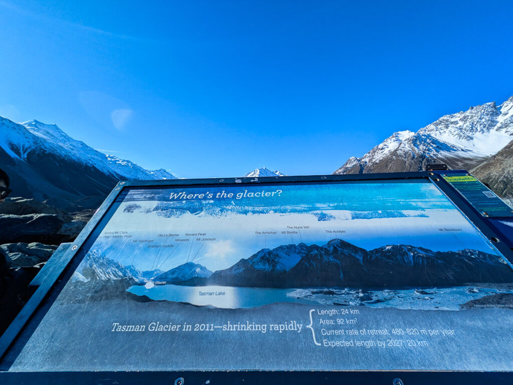
As the sign says, the Blue Lakes are now a nice shade of green (or, in my opinion, teal). This is because the glacier has receded so much that glacial water no longer flows into these lakes. Instead, they are now filled with warmer rainwater, which allows algae to grow.
It’s a nice peaceful spot to have lunch. Most of the crowds don’t make it here, and it’s also less exposed to the wind.
Tasman Lake & Tasman River
Tasman Lake and jetty (2.6km return)
The Tasman Lake track is used to access the lake for the boat tours, but the jetty is public, so anyone can visit regardless of whether you are part of a tour or not. Try to avoid the boat tour timings if you can, so that you’re not sharing the area with large groups.

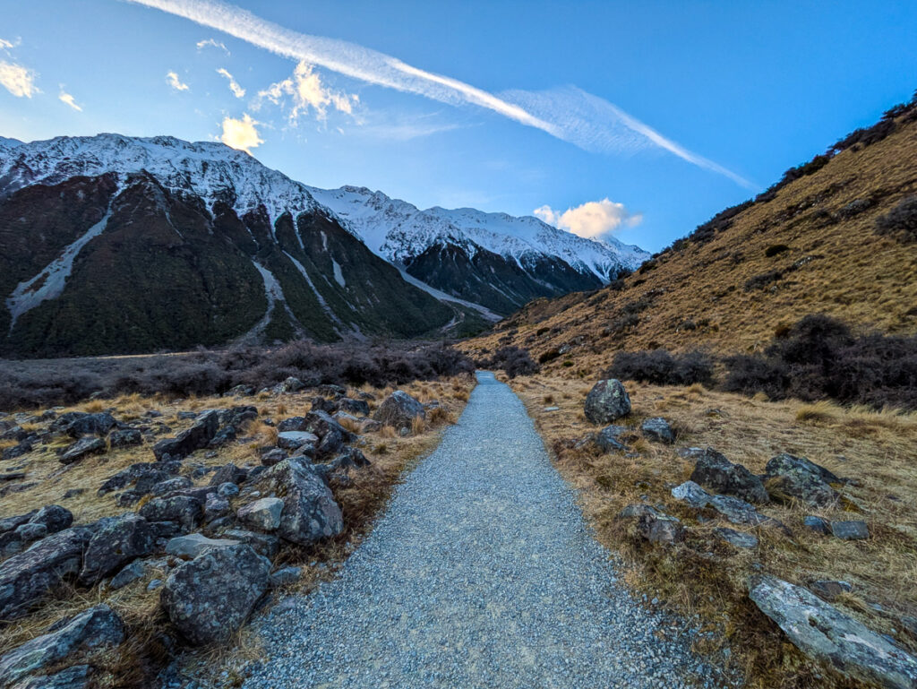
This track is paved with gravel from start to finish, and the gravel path is wide, flat, and even. All of this makes it a very, very accessible track, the sort of thing that you can do with your grandmother.
You start by walking through the Tasman Valley, across fields of dense scrub strewn with boulders and surrounded by mountains.

After a nice relaxing stroll, you’ll eventually arrive at a fork, with the Tasman Lake and jetty lookout in one direction, and the Tasman River lookout in the other.
Truthfully, if you’re not doing a boat tour, you can just skip the Tasman Lake and jetty lookout. It has nice views, but nothing that you can’t get from the Tasman River lookout. There aren’t many icebergs near the jetty, and the large number of manmade structures in the area detract from the natural beauty around you. In my opinion, anyway.
Instead, I’d recommend you take the other path at the fork, which will lead you to…
Tasman River side track
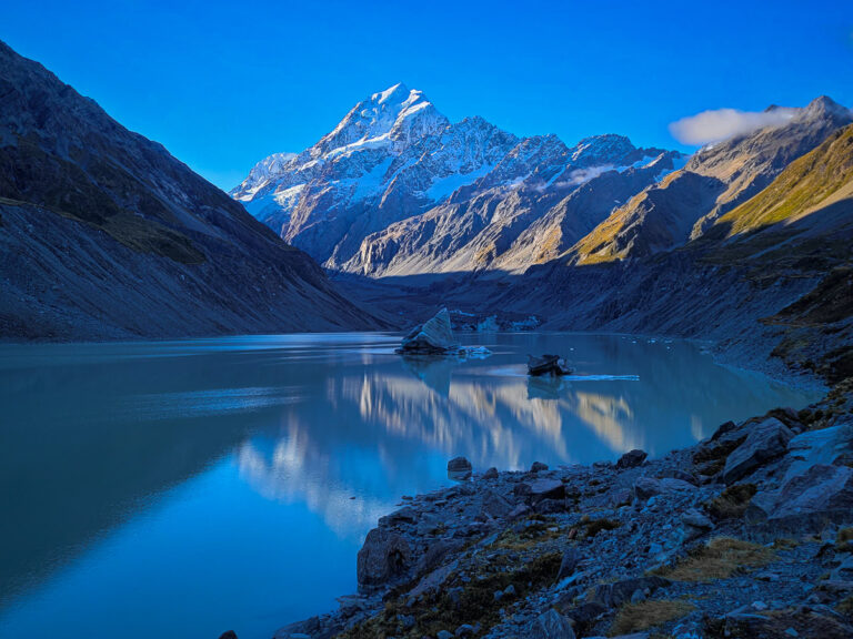
The Tasman River lookout is phenomenal. Mind-blowing. Ridiculously picturesque.
It’s my favorite out of all the tracks in the Tasman Glacier area, and rivalled only by the final lookout on the Hooker Valley walk. Which, by the way, makes it tied for my favorite track in all of New Zealand.
I mean, you get to walk right up to enormous icebergs calved from a glacier! And they’re floating on this ethereal blue glacial lake! Surrounded by snow-capped mountains!! How do you beat that?!
Unfortunately, we weren’t alone in this sentiment. There were a surprising number of people at the Tasman River lookout, considering its relative obscurity. To be fair, we were there at sunset, which is often a popular time of the day.
Here’s the thing, though. The track officially ends at the rocks that stand between you and the lake.
But getting down those rocks isn’t too difficult. Of course, since it’s not part of the official track, it’s unmaintained and if you choose to descend the rocks, you’ll do it at your own risk. But there also isn’t any signage telling you not to do it, and no warnings by the DOC (that I could find).

I have exceptionally poor balance and I managed the short scramble just fine. It took me roughly 20 minutes to get all the way down, as I needed to choose my footing carefully. Getting back up was a lot faster, around 10 minutes.
You do need sturdy footwear, preferably hiking shoes. I saw people doing it in all sorts of city shoes, but I wouldn’t recommend it.
Once you get all the way down to the lakeshore, the crowds thin out, as there’s a bigger space for everyone to disperse. And then you’re treated to the most magical views.

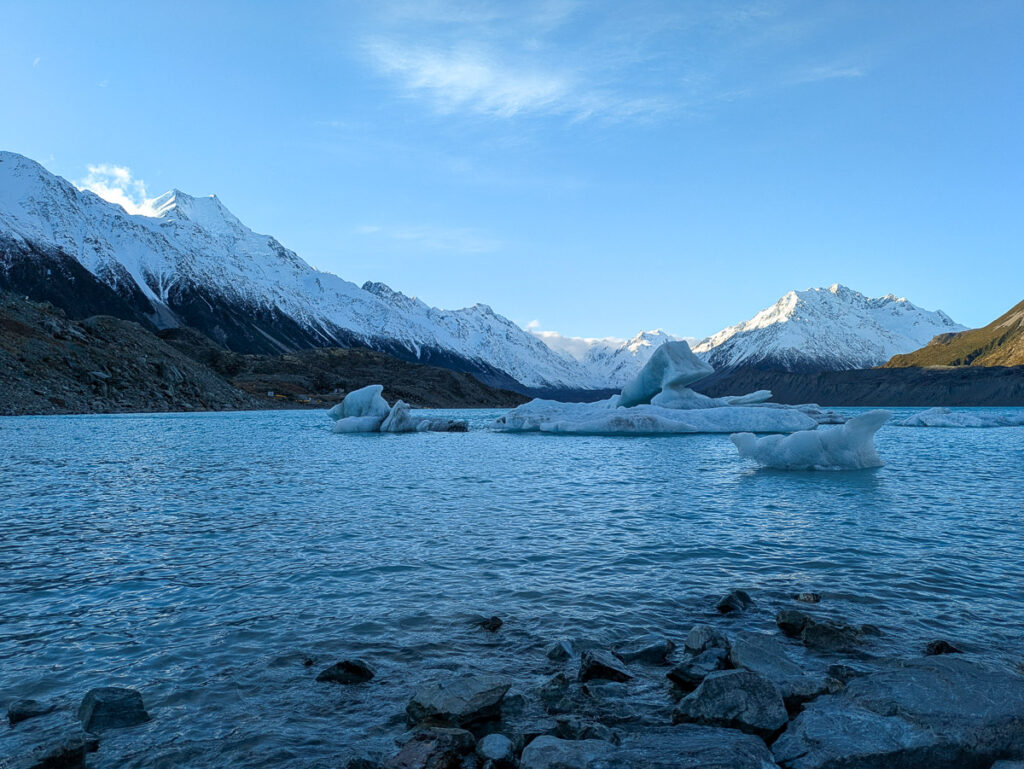
You see, the lookout is conveniently located at the point where Tasman Lake flows into Tasman River. And so the icebergs, having calved from the glacier, meander down the lake until they arrive here, at which point they get stuck.
They’re too big to make it through the bottleneck that leads from the lake into the river. That’s why there are so many icebergs here – they’re all waiting to melt or split into pieces small enough to make the journey downstream.
It all feels rather poetic, don’t you think?

But anyway, if you like icebergs or glacial lakes even the tiniest bit, you need to do the Tasman River track, and you need to scramble down the rocks to the lakeshore. It was 101% worth it (even though I was sore the next day!).
Should you still do the Tasman Lake boat ride after doing these walks?
Ehhh, it depends.
If you are reasonably fit and you just want to be up close to icebergs, there isn’t really any point in taking the boat ride. You’ll get close enough to touch the icebergs if you do the Tasman River track and scramble down the rocks.

But if you have elderly people or anyone with mobility issues in your group, or just don’t feel comfortable doing rock scrambling, and you really want to touch and see icebergs in a glacial lake… then yes the boat ride is probably worth it.
To the best of my knowledge there is only one operator doing boat rides in the lake – Glacier Explorers, which is run by Hermitage Hotel in Mount Cook Village. The other tour operators will use their services on the lake, but might add on their own (e.g. transporting you to and from a larger base like Queenstown).
It is fairly expensive – as of September 2025 the base tour will cost you $195 per adult. I don’t know if the boat ride will bring you all the way up to the glacier face, as the glacier has receded so much over the years.
Should you do these walks even after the Hooker Valley walk reopens?
Absolutely, yes.
In my mind both walks are equally good, but they are also very different. The Hooker Valley walk takes you through the valley on the left side of Ball Pass, showing you Hooker Lake, Mueller Lake, and Hooker River. It’s a flat walk with no elevation gain, and Mount Cook is the star of the show after the second swing bridge.
The Tasman Glacier walks go through the right hand side of Ball Pass, and they offer a variety of options: A high lookout point with sweeping views that include (but are not dominated by) Mount Cook, a shoreline track that lets you touch icebergs, and a view of the Blue Lakes.
It is most definitely worth doing everything if you enjoy hiking even the tiniest bit. You might want to do Hooker Valley and the Tasman Glacier walks on different days unless you’re very fit.
Additional tips
- You can technically do all of the walks starting from the Tasman Glacier carpark in just over an hour if you hurry, but I’d allocate half a day for them. The views along the tracks are so phenomenal that I’d want to have plenty of time to take photos, enjoy the sights, and maybe have a picnic.
- The toilets at the Tasman Glacier carpark are closed during the winter, so if you’re visiting during that time, pee before leaving the village!
- Wear sunscreen and a big hat. At 700m above sea level, Mount Cook National Park sits at a higher elevation than the native tree line. Some imported trees do survive at a higher altitude, however for obvious reasons they aren’t planted in national parks. Due to this, all of the walks here are completely exposed to sun during the middle of the day. And there’s a big hole in the ozone right above NZ, so even when it’s cold, the sun can be brutal.
- Bring windproof and waterproof clothing. While Mount Cook National Park tends to be a lot dryer than the western side of the mountains, the weather can change with very little notice. And the higher up you go in the mountains, the stronger the wind can get.

Hello, can we do this Tasman Glacier walk without a guide?
Hi Fransisca, yes you absolutely can! All of these walks have a clear path and signage, there isn’t any risk of getting lost. They are also all accessible to the public, as long as you have a car or some other way of accessing the trailhead.